
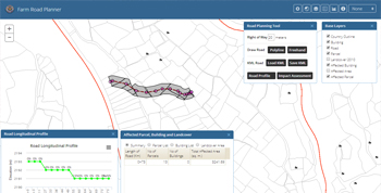
The application supports in the planning exercise of farm road construction in Bhutan. It helps in feasibility study of road construction by providing longitudinal profile of the road which consists of information such as elevation and slope profiles. It also helps in carrying out an impact assessment in terms of buildings and land parcels which will be affected by road construction.
A sample dataset consisting of land parcel and building are used in the application to calculate the potentially affected buildings and lands in the event of farm road construction. The land cover data of Bhutan for 2010 is used to determine the area distribution of affected land cover types. Further, the Shuttle Radar Topography Mission (SRTM) 90m digital elevation model data is used to find out the longitudinal profile of the road.
The application provides Polyline and Freehand tools for drawing/digitizing a road on map. It allows saving the digitized road as a KML file which the users can view in Google Earth or load to the application at a later date. Also, it offers Road Profile and Impact Assessment tools each of which carries out on-the-fly spatial analyses and generates useful information with regards to planning of road construction:
Road Profile Tool: It generates a chart of longitudinal profile of road giving information on length, elevation and slope of each chainage of the road.
Impact Assessment Tool: It provides information such as length of digitized road, affected parcel area and buildings and on affected land cover types. It also allows users to view affected land parcels and buildings on map.